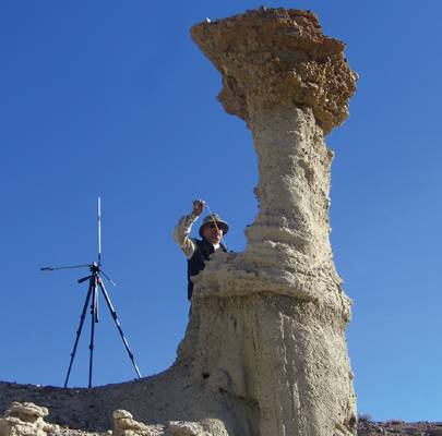
Hoodoos: Key to Earthquakes?
In the absence of long-term instrumental data, fragile rock formations, called hoodoos, may be key to understanding seismic hazard risk. In a new study published in the Bulletin of the Seismological Society of America (BSSA), researchers consider two hoodoos in Red Rock Canyon region to put limits on expected intensity of ground motion from earthquakes along the Garlock fault. Hoodoos can be found in desert regions and are highly susceptible to erosion that makes their age uncertain. Despite that uncertainty, existing unfractured hoodoos, tall spires of sedimentary rock, may help put limits on ground motion associated with recent events by understanding the minimal force necessary to break the shafts made primarily of relatively soft sandstone. The Garlock fault region features an active strike-slip fault. Anooshehpoor, et al., estimated the tensile strength of two hoodoos and considered previously published physical evidence of fault offsets that suggest at least one large earthquake, resulting in seven meters (23 feet) of slip, in the last 550 years. And yet, the hoodoos are still intact, suggesting median or low level of ground motion associated with the large quakes in this region. While the age of the hoodoos cannot be exactly ascertained, the authors argue that these rocks can still serve as a valuable tool in constraining ground motion and thus contribute to the development of probabilistic seismic hazard assessments in the area.
In the absence of long-term instrumental data, fragile rock formations, called hoodoos, may be key to understanding seismic hazard risk. In a new study published in the Bulletin of the Seismological Society of America (BSSA), researchers consider two hoodoos in Red Rock Canyon region to put limits on expected intensity of ground motion from earthquakes along the Garlock fault.
Hoodoos can be found in desert regions and are highly susceptible to erosion that makes their age uncertain. Despite that uncertainty, existing unfractured hoodoos, tall spires of sedimentary rock, may help put limits on ground motion associated with recent events by understanding the minimal force necessary to break the shafts made primarily of relatively soft sandstone.
![]()

The Garlock fault region features an active strike-slip fault. Anooshehpoor, et al., estimated the tensile strength of two hoodoos and considered previously published physical evidence of fault offsets that suggest at least one large earthquake, resulting in seven meters (23 feet) of slip, in the last 550 years. And yet, the hoodoos are still intact, suggesting median or low level of ground motion associated with the large quakes in this region.
While the age of the hoodoos cannot be exactly ascertained, the authors argue that these rocks can still serve as a valuable tool in constraining ground motion and thus contribute to the development of probabilistic seismic hazard assessments in the area.
Constraints on Ground Accelerations Inferred from Unfractured Hoodoos near the Garlock Fault, California
James N. Brune, Jaak Daemen, and Matthew D. Purvance
University of Nevada, Reno, 1664 N. Virginia Street, Reno, Nevada 89557
Abstract
In the absence of long?term instrumental data, the presence of fragile geologic features near active faults can provide physical limits on the level of ground shaking that could potentially have significant implications for seismic hazards. This paper introduces a multidisciplinary investigation that uses unfractured hoodoos in seismically active regions to constrain the level of ground accelerations at those locations. Although there is a large uncertainty associated with the age of the hoodoos because of their rapidly eroding nature, they can still be useful in providing physical limits on ground motions associated with recent large events. Here, we consider the fragilities of two hoodoos in the Red Rock Canyon region within a few kilometers of the Garlock fault, which is an active strike?slip fault in a transtensional region with at least a few large earthquakes in the Holocene. The hoodoos at these sites could be evidence of median or relatively low ground motions associated with large transtensional strike?slip earthquakes. Results of our field and laboratory tests on two hoodoos provide constraints on peak ground accelerations (PGAs) of and . Using the U.S. Geological Survey’s (USGS) probabilistic seismic hazard (PSH) deaggregation, the dominant earthquake contributing to the hazard at the site of the hoodoos for the recurrence intervals of 475, 975, and 2475 years is located at a distance of 4.8 km and has a magnitude of 7.63, consistent with the observed paleoearthquake evidence on the Garlock fault. The PGAs corresponding to these three return periods are 0.26, 0.40, and , respectively. Therefore, the survival of the more fragile hoodoo during a presumably large event on the Garlock fault in the past 550 years would be consistent with the 2008 seismic hazard level if the ground motions during that event were below the median value.
